Havasupai
Hopi
Hualapai
Legends
Leaders
Events
Kaibab Paiute
Navajo
White Mountain Apache
Save the Peaks!
Merriam Report
Credits
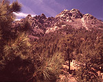
The Hualapai mountain range is located in Mohave County, Arizona. The Hualapai were living in this mountain range when they first encountered Anglo-Americans. These mountains are the biggest and most ancient in Mohave County, with an elevation height of 8417 feet above sea level. The Hualapai Indians derived their name as a result of their habitation in these pine covered mountains.
The Hualapai Mountains Park. In the 1930s, the Civilian Conservation Corps founded this Mohave County park. There are trails, picnic spots, camping areas, and cabins available to rent.
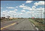
Historic Route 66 passes through a number of places such as the Hualapai Indian Reservation, Kingman, Seligman, Oatman, Grand Canyon Caverns, and Peach Springs.
Digital Resources
Route 66
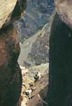
The Colorado River is an important landmark for the Hualapai. It is Mohave County's chief source of freshwater. According to historians, all the family tribes that spoke the Yuman language were living near the Colorado River in the past.
Digital Resources
Colorado River
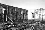
Fort Mohave was founded in 1859 by Col. Hoffman of the U.S. army and his command on the Arizona side of the Colorado River. Major Lewis A. Armstead assumed control after Col. Hoffman's departure. However, Major Armstead lost his life at Gettysburg at the time of the American Civil War. Fort Mohave served to better the relations between the various Native-American tribes and the Anglo Americans. Although the Fort was deserted in 1861, it was taken up in 1863. Later in 1890, it served as a school and was closed again in 1934.
Digital Resources
Fort Mohave